File:Will of John Turner.pdf
Will_of_John_Turner.pdf (file size: 5.35 MB, MIME type: application/pdf)
The image was obtained from the records kept at the Library of Virginia. The majority of this image consists of the will of John Turner.
Other Pages:
Image Source Data
Format	BK
Leader	00607npm  2200193Ka 4500
Fixed-Length Field	980520s1764    vau           000   eng d
Cataloging Source	 VIC VIC
Title	 Turner, John.
Publication Area	 1764
General Note	 Part of index to Halifax County Wills and Administrations (1753 - 1800)
Local Note	   p. 180-181. Will pro. 21 June 1764.
Local Note	   p. 197-198. Inv. & Appr. rec. 21 Mar. 1765.
Local Note	   Will Book No. 0, 1753-1772 (Reel 36)
Subject-Name	 Turner, John,
Subject-Geographic	 Halifax County (Va.)
Index Term-Genre/Fo	 Wills.
Add Rel/Anal Title	 Virginia wills and administrations.
Local Note	 ARC TOR
Bibliography format	 0764/W0174?44
SRC	 LVA01 clas08.aa
Sys.No.	000537938
Transcript
This transcript comes from http://www.genealogy.com/forum/surnames/topics/chadwell/533/
It is obviously incomplete.
1762 Nov 1 - Halifax Co, Va - Will Bk O:180 - Proved: 21 Jun 1764
Will of JOHN TURNER written; Proved: 21 June 1764.
I, JOHN TURNER, sick & weak in body...
#1 - To my wife, 6 head of horse creatures, 3 cows, 2 calves & 1 heifer & «
of:
hogs, household goods & chattles, peace of land at PERTOMUCK on GOOSE
CREEK & 4 sheep whom I likewise appt my Executrix..
#2 - To my son JAMES TURNER - 6 horse creatures & a piece of land on SMITH
RIVER BETWEEN ANGELS FALLS & NICHELLASES CREEK
#3 - To my daughters, ELIZABETH TURNER & JESSIE TURNER a piece of
land called BUTRAMTOWN to be equally divided between them...
#4 - The other half of my household goods & chattles & half my cattle & hogs
to be
divided between my 6 CHILDREN I HAD BY MY FIRST WIFE..
#5 - To my other TWO DAUGHTERS, JEMIMA TURNER & MARY TURNER
a piece of land on SMITH RIVER WHERE I DID FORMERLY LIVE ON
SOUTH SIDE OF RIVER about one mile below the MOUTH OF GOBLINTOWN
CREEK..
#6 - To my son JOHN TURNER & MY SON ISREAL TURNER one NEGRO
BOB to be divided between them when they come of age 18.. If they cannot agree
for one to keep him & pay the other or sold & money divided..
#7 - To son ISREAL TURNER, a peace of land on GBLINTOWN CREEK at the
MOUTH OF SHOL BRANCH..
#8 - To son JOHN, 1 rifle gun and labour of the NEGRO I devised to be for to
raise the 6 CHILDREN as I had BY MY FIRST WIFE TILL ONE OF THE BOYS
IS 18 YEARS OLD.
Wit: Archibald Thompson, Samuel Crowley, James Strong.Exec: wife (2nd)
ELIZABETH.Security Bond: Merry Webb & Samuel Crowley

1764 Jun 21 - Last will of JOHN TURNER dec'd presented by ELIZABETH
TURNER one of the Exec.. Security Bond by Merry Webb & Samuel Crowley
[Children:
Son: JAMES TURNER, land on Smith River
Dau: Elizabeth Turner, land on Butramtown Creek
Dau: Jessie Turner, land on Butramtown Creek
Dau: Jemima Turner, land on Smith River below Goblintown Creek
Dau: Mary Turner, land on Smith River below Goblintown Creek
Son: JOHN TURNER, under 18 in 1762 (b.1744-1762)
*Son: ISRAEL TURNER, land on Goblintown Creek;NEGRO: BOB; Israel
under age 18 (b.1744-1762).Inventory: 25 Feb 1765 - Appraised by John
Talbot, Patrick Sheilds, Samuel Shields.
Notes
Important People Mentioned
- James Turner
- Elizabeth Turner
- Jessie Turner
- Jemima Turner
- Mary Turner
- John Turner, Jr.
- Israel Turner
Slave Bob
The Will of Israel Turner mentions the slave, Bob.
Goose Creek Land
The wife's inherited land is along Goose Creek at the Potomac. This area can be found on the contemporary map below at 300,39.
-
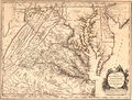
A map of Virginia dating from around 1757.

Smith River Land
The Smith River is shown on the contemporary map, but not named as such. (It appears to be named Irvine River on this map, a variation attested to on Wikipedia.) It can be found below 37 and to the left of 298. Goblintown Creek is a tributary to this river, and is not obviously labeled or drawn in at all. Currently, the connection between Goblintown Creek and the Smith River is currently broken by Philpott Lake, which is a reservoir created with the construction of the Philpott Dam between 1948 and 1952. The map from the planning of the Philpott Dam shows land boundaries in the area from at the time of the dam's planning.
-
A map of Virginia dating from around 1757.
-

Philpott Dam, planning map, below Goblintown Creek junction

See:
- Smith River (Virginia) - Wikipedia
- Philpott Lake - Wikipedia
File history
Click on a date/time to view the file as it appeared at that time.
| Date/Time | Dimensions | User | Comment | |
|---|---|---|---|---|
| current | 04:37, 5 October 2016 | (5.35 MB) | Seanmcox (talk | contribs) | The image was obtained from the records kept at the Library of Virginia. == Image Source Data == <pre> Format BK Leader 00607npm 2200193Ka 4500 Fixed-Length Field 980520s1764 vau 000 eng d Cataloging Source VIC VIC Title Turner, John... |
You cannot overwrite this file.
File usage
The following 2 pages use this file: