Henry County, Virginia: Difference between revisions
(→Land Records: Added record.) |
(→Land Records: Added sources.) |
||
| Line 19: | Line 19: | ||
File:Virginia Land Office Patents and Grants, Northern Neck Grants and Surveys, Patents No.31 1751-1756 (VOL.1 & VOL.2), pages 636, 637.tif|Virginia Land Office Patents and Grants, Northern Neck Grants and Surveys, Patents No.31 1751-1756 (VOL.1 & VOL.2), pages 636, 637 | File:Virginia Land Office Patents and Grants, Northern Neck Grants and Surveys, Patents No.31 1751-1756 (VOL.1 & VOL.2), pages 636, 637.tif|Virginia Land Office Patents and Grants, Northern Neck Grants and Surveys, Patents No.31 1751-1756 (VOL.1 & VOL.2), pages 636, 637 | ||
File:Virginia Land Office Patents and Grants, Northern Neck Grants and Surveys, Patents No.39 1770-1771, pages 222, 223.tif|Virginia Land Office Patents and Grants, Northern Neck Grants and Surveys, Patents No.39 1770-1771, pages 222, 223 | File:Virginia Land Office Patents and Grants, Northern Neck Grants and Surveys, Patents No.39 1770-1771, pages 222, 223.tif|Virginia Land Office Patents and Grants, Northern Neck Grants and Surveys, Patents No.39 1770-1771, pages 222, 223 | ||
File:Virginia Land Office Patents and Grants, Northern Neck Grants and Surveys, Patents No.40 1771-1772, pages 688, 689.tif|Virginia Land Office Patents and Grants, Northern Neck Grants and Surveys, Patents No.40 1771-1772, pages 688, 689 | |||
File:Virginia Land Office Patents and Grants, Northern Neck Grants and Surveys, Patents No.40 1771-1772, pages 690, 691.tif|Virginia Land Office Patents and Grants, Northern Neck Grants and Surveys, Patents No.40 1771-1772, pages 690, 691 | |||
File:Virginia Land Office Patents and Grants, Northern Neck Grants and Surveys, Patents E 1775-1776,1780-1781 (VOL.1 & VOL.2), page 650.tif|Virginia Land Office Patents and Grants, Northern Neck Grants and Surveys, Patents E 1775-1776,1780-1781 (VOL.1 & VOL.2), page 650 | File:Virginia Land Office Patents and Grants, Northern Neck Grants and Surveys, Patents E 1775-1776,1780-1781 (VOL.1 & VOL.2), page 650.tif|Virginia Land Office Patents and Grants, Northern Neck Grants and Surveys, Patents E 1775-1776,1780-1781 (VOL.1 & VOL.2), page 650 | ||
File:Virginia Land Office Patents and Grants, Northern Neck Grants and Surveys, Patents E 1775-1776,1780-1781 (VOL.1 & VOL.2), page 651.tif|Virginia Land Office Patents and Grants, Northern Neck Grants and Surveys, Patents E 1775-1776,1780-1781 (VOL.1 & VOL.2), page 651 | File:Virginia Land Office Patents and Grants, Northern Neck Grants and Surveys, Patents E 1775-1776,1780-1781 (VOL.1 & VOL.2), page 651.tif|Virginia Land Office Patents and Grants, Northern Neck Grants and Surveys, Patents E 1775-1776,1780-1781 (VOL.1 & VOL.2), page 651 | ||
Revision as of 19:22, 18 September 2016
Formed from Pittsylvania County in 1777.
This is a county where William Cox lived during the late 1700's.
The Carolina Road was a major thoroughfare for migration beginning in the 1740's for Scots-Irish and Swiss-German settlers from Pennsylvania and Virginia.[1]
Smith River and Philpott Lake
The Smith River is shown on the Map of Virginia published in 1770, but not named as such. It appears as the Irvine River on this map, and was named thus after Alexander Irwin an early surveyor of the area. (The Mayo River a little further west was named after William Mayo, another early surveyor of the area.)[2][3] It can be found below 37 and at about 30-3. The path of the Smith River is currently broken by Philpott Lake, which is a reservoir created with the construction of the Philpott Dam between 1948 and 1952. Review of various maps shows what appears to be significant inconsistencies in the path of the Smith River. (Compare the 1859 map on page 10, figure 2 of the Architectural Survey of Henry County, Virginia, 2009, the 1911 Roadmap of Henry County, Virginia, and Google Maps.) Some investigation should be pursued to identify verify that the path of the river has changed significantly over the course of the last 200 years.
See:
- Smith River (Virginia) - Wikipedia
- Philpott Lake - Wikipedia
- Philpott Dam - Wikipedia
- Philpott Lake - U.S. Army Corp of Engineers: Wilmington District
Land Records
-
Virginia Land Office Patents and Grants, Northern Neck Grants and Surveys, Patents No.31 1751-1756 (VOL.1 & VOL.2), pages 634, 635
-

Virginia Land Office Patents and Grants, Northern Neck Grants and Surveys, Patents No.31 1751-1756 (VOL.1 & VOL.2), pages 636, 637
-
Virginia Land Office Patents and Grants, Northern Neck Grants and Surveys, Patents No.39 1770-1771, pages 222, 223
-
Virginia Land Office Patents and Grants, Northern Neck Grants and Surveys, Patents No.40 1771-1772, pages 688, 689
-
Virginia Land Office Patents and Grants, Northern Neck Grants and Surveys, Patents No.40 1771-1772, pages 690, 691
-
Virginia Land Office Patents and Grants, Northern Neck Grants and Surveys, Patents E 1775-1776,1780-1781 (VOL.1 & VOL.2), page 650
-
Virginia Land Office Patents and Grants, Northern Neck Grants and Surveys, Patents E 1775-1776,1780-1781 (VOL.1 & VOL.2), page 651
,_pages_634,_635.png)
See:
- Henry County, Virginia - Zillow
- GIS Maps - Henry County, Virginia
Abstract of Henry County, Virginia vol. 1
- Found in the Family History Library in Salt Lake, City
- US/Canada Books 975.5692 R28a
- This transaction, along with a few others, connect William Cox with Smith River in Henry County, where another Cox family was located.
- p. 51
Deed pgs 283, 284
28 October 1779
WILLIAM COX and JEMIMAH COX his wife of the county of Henry to CARR BAILEY of the same for the sum of fifty pounds sells land, etc as may more fully appear in the pattent granted DAVID HALEY in the year 1755 10th September. This land on the south side of Smith River and contains 40 acres.WILLIAM COX
JEMIMAH COX
Supplemental Information
- From http://wc.rootsweb.ancestry.com/cgi-bin/igm.cgi?op=GET&db=bh342&id=I06371
- David Haley is reported to have sold his 40 acre parcel on the south side of the Smith river to John Turner on 20 Jan 1757. Presumably this is the same John Turner who's daughter, Jemima Turner married William Cox, which would explain how William Cox, with Jemima, is found to be selling the land to Carr Bailey in 1779.
- John Turner's will (he died about 1764) records that he left a piece of land on the south side of the Smith River to his daughter Jemima, William Cox's wife. The will places the plot where the Goblintown Creek empties into the Smith River, which is an area now largely underwater.
- Records can be sought through the Library of Virginia
- The patent granted DAVID HALEY in the year 1755 10th September, appears to be available in the Library of Virginia, though, their website gave an error when I tried to download the record.
- Based on other land grant records, David Haley would have owned a plot of land near where the Town Creek meets the Smith River.
Resources
-
Map of Virginia published in 1770. Henry County was formed in the area of the south-eastern half of what is here labeled the Irvin River, but which came to be called the Smith River.
-
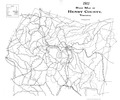
1911 Roadmap of Henry County, Virginia.
-

R. P. Stephen Davis, Jr., Jane Eastman, Thomas O. Maher, and Richard P. Gravely, Jr., "ARCHAEOLOGICAL INVESTIGATIONS AT THE PHILPOTT SITE, HENRY COUNTY, VIRGINIA", Research Laboratories of Archaeology: The University of North Carolina at Chapel Hill, 1998
-
Architectural Survey of Henry County, Virginia, 2009

- Map - Google Maps
- Henry County, Virginia - Topozone
- Henry County, Virginia - Wikipedia
- MyHenryCounty.com
- Bassett Historical Center
- Ancestry.com. A history of Henry County, Virginia : with biographical sketches of its most prominent citizens and genealogical histories of half a hundred of its oldest families. [database on-line]. Provo, UT: Ancestry.com Operations Inc, 2005.
Original data: Hill, Judith Parks America.. A history of Henry County, Virginia : with biographical sketches of its most prominent citizens and genealogical histories of half a hundred of its oldest families. unknown: unknown, 1925.]
References
- ↑ Carolina Road - Wilderness Road
- ↑ "Smith River" - USGS: Geographic Names Information System
- ↑ Clement, Maude Carter (2004) [1929]. "Chapter II: Natural Conditions". The History of Pittsylvania County Virginia. Santa Maria, California: Janaway Publishing, Inc. p. 26. ISBN 9780974195797. "The next two rivers were named Irwin and Mayo in honor of the two surveyors, Alexander Irwin and William Mayo."